
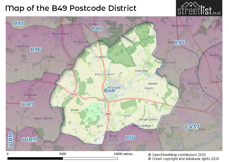
Map of the B49 Postcode District
Explore the postcode district by using our interactive map.
Circles represent recorded crime; the larger the circle, the higher the crime rates.
Your support helps keep this site running!
If you enjoy using this website, consider buying me a coffee to help cover hosting costs.
Where is the B49 District?
To give you an idea where the district is located we have created the following table showing nearby towns.
Nearest Towns to B49
| Town | Distance (miles) | Direction |
|---|---|---|
| Henley-in-Arden | 6.36 | NE |
| Redditch | 6.95 | NNW |
| Stratford-upon-Avon | 7.05 | ESE |
| Evesham | 9.26 | SSW |
| Pershore | 11.48 | SW |
| Bromsgrove | 11.52 | NW |
| Chipping Campden | 12.11 | SSE |
| Droitwich Spa | 12.32 | WNW |
| Warwick | 12.67 | ENE |
| Solihull | 14.04 | NNE |
| Whitnash | 14.82 | ENE |
| Shipston-on-Stour | 14.88 | SE |
| Kenilworth | 14.99 | NE |
| Royal Leamington Spa | 14.99 | ENE |
| Worcester | 15.11 | W |
| Moreton-in-Marsh | 17.20 | SSE |
| Birmingham | 18.18 | N |
| Halesowen | 18.27 | NNW |
| Winchcombe | 18.69 | SSW |
The post town for this district is ALCESTER.
Postcode Information for District B49 (Total Geographical Postcodes: 392)
| Location | Post Town | Sector | Number of Postcodes |
|---|---|---|---|
| ALCESTER | ALCESTER | B49 5 | 101 |
| ALCESTER | ALCESTER | B49 6 | 98 |
| Great Alne | ALCESTER | B49 6 | 34 |
| Cookhill | ALCESTER | B49 5 | 24 |
| Oversley Green | ALCESTER | B49 6 | 17 |
| Kinwarton | ALCESTER | B49 6 | 13 |
| Coughton | ALCESTER | B49 5 | 12 |
| Temple Grafton | ALCESTER | B49 6 | 12 |
| Haselor | ALCESTER | B49 6 | 11 |
| Dunnington | ALCESTER | B49 5 | 10 |
| Kings Coughton | ALCESTER | B49 5 | 9 |
| Wixford | ALCESTER | B49 6 | 8 |
| Weethley | ALCESTER | B49 5 | 7 |
| Shelfield | ALCESTER | B49 6 | 7 |
| Arrow | ALCESTER | B49 5 | 6 |
| Ardens Grafton | ALCESTER | B49 6 | 6 |
| Coughton | ALCESTER | B49 6 | 3 |
| Coldcomfort | ALCESTER | B49 5 | 2 |
| Walcote | ALCESTER | B49 6 | 2 |
| Billesley | ALCESTER | B49 6 | 2 |
| Redhill | ALCESTER | B49 6 | 2 |
| Knighton | ALCESTER | B49 5 | 2 |
| Exhall | ALCESTER | B49 6 | 2 |
| Wood Bevington | ALCESTER | B49 5 | 1 |
| Knowle Fields | ALCESTER | B49 5 | 1 |
Retail and Shopping in B49
Street
Town
Locality
Number of Shops
Central Postcode
View on Google Maps
HIGH STREET
ALCESTER
56
B49 5AD
View on Google Maps
SWAN STREET
ALCESTER
15
B49 5DP
View on Google Maps
KINWARTON ROAD
ALCESTER
7
B49 6AA
View on Google Maps
ARDEN FOREST INDUSTRIAL ESTATE
ALCESTER
6
B49 6ES
View on Google Maps
BULLS HEAD YARD
ALCESTER
6
B49 5BX
View on Google Maps
| Street | Town | Locality | Number of Shops | Central Postcode | View on Google Maps |
|---|---|---|---|---|---|
| HIGH STREET | ALCESTER | 56 | B49 5AD | View on Google Maps | |
| SWAN STREET | ALCESTER | 15 | B49 5DP | View on Google Maps | |
| KINWARTON ROAD | ALCESTER | 7 | B49 6AA | View on Google Maps | |
| ARDEN FOREST INDUSTRIAL ESTATE | ALCESTER | 6 | B49 6ES | View on Google Maps | |
| BULLS HEAD YARD | ALCESTER | 6 | B49 5BX | View on Google Maps |
The primary settlement in the B49 postcode district is Alcester, located in the county of Warwickshire, England. Other significant settlements in this district include Arrow, Coldcomfort, Cookhill, Coughton, Dunnington, Kings Coughton, Knowle Fields, Weethley, and Wood Bevington. There is also a settlement called Cookhill located in Worcestershire, and Knighton located in Worcestershire as well. The most significant post town in this district is Alcester.
When it comes to local government, postal geography often disregards political borders. However, this district intersects the following councils: the district mostly encompasses the Stratford-on-Avon District (360 postal codes), and finally, the Wychavon District area (22 postal codes).
The largest settlement in the B49 postal code is ALCESTER followed by Great Alne, and Cookhill.
The B49 Postcode shares a border with B95 (HENLEY-IN-ARDEN, Wootton Wawen, Ullenhall), WR7 (Inkberrow, Crowle, Upton Snodsbury), B50 (Bidford-on-Avon, Broom), B80 (STUDLEY, Mappleborough Green, Morton Bagot) and B96 (Astwood Bank, Feckenham, Sambourne).


Dentists in the B49 District
| # | Name | Address | Type | Contact |
|---|---|---|---|---|
| 1 | Dental Practice | OLD TILE HOUSE MARKET PLACE , HIGH STREET , ALCESTER , WARWICKSHIRE , B49 5AE | GENERAL DENTAL PRACTICE | |
| 2 | Dental Surgery | 19 PRIORY ROAD , ALCESTER , WARWICKSHIRE , B49 5DX | GENERAL DENTAL PRACTICE |
Doctors in the B49 District
| # | Name | Address | Type | Contact |
|---|---|---|---|---|
| 1 | Alcester Health Centre | , ALCESTER , WARWICKSHIRE , B49 6QR | GP PRACTICE | |
| 2 | The Arrow Surgery | , ALCESTER , WARWICKSHIRE , B49 6QR | GP PRACTICE |
Chemists in the B49 District
| # | Name | Address | Type | Contact |
|---|---|---|---|---|
| 1 | Hopkins Pharmacy | ALCESTER PRIMARY CARE CENTRE , FIELDS PARK DRIVE , ALCESTER , WARWICKSHIRE , B49 6QR | PHARMACY | |
| 2 | Delivermymeds | RIGHT HAND GRAFTON HOUSE , BULLS HEAD YARD , ALCESTER , WARWICKSHIRE , B49 5BX | PHARMACY | |
| 3 | Alcester Pharmacy | 51-53 HIGH STREET , ALCESTER , B49 5AF | PHARMACY |
Opticians in the B49 District
| # | Name | Address | Type | Contact |
|---|---|---|---|---|
| 1 | MICHAEL BEAVER OPTICIANS | 20 HIGH STREET , ALCESTER , WARWICKSHIRE , B49 5AD | OPTICAL SITE | |
| 2 | ALCESTER OPTICIANS | 65 HIGH STREET , ALCESTER , WARWICKSHIRE , B49 5AF | OPTICAL SITE | |
| 3 | ALCESTER SPECSAVERS | 36 HIGH STREET , ALCESTER , B49 5AA | OPTICAL SITE |
Schools in the Sector
Alcester Grammar School
Phase: Secondary
Address: Birmingham Road , Alcester
Postcode: B49 5ED
Headteacher: Mr I G Blaikie (Headteacher)
Ofsted Rating: Outstanding
Alcester Grammar School
Phase: Secondary
Address: Birmingham Road , Alcester
Postcode: B49 5ED
Headteacher: Ms Rachel Thorpe (Principal)
Ofsted Rating: Outstanding
Coughton CofE Primary School
Phase: Primary
Address: Coughton Lane , Coughton , Alcester
Postcode: B49 5HN
Headteacher: Mr Adam Walsh (Headteacher)
Ofsted Rating: Good
Coughton CofE Primary School
Phase: Primary
Address: Coughton Lane , Coughton , Alcester
Postcode: B49 5HN
Headteacher: Mr Alex Kolb (Headteacher)
Ofsted Rating: Good
Dunnington CofE Primary School
Phase: Primary
Address: Dunnington , Alcester
Postcode: B49 5NT
Headteacher: Miss Fiona Templeton (Headteacher)
Ofsted Rating: Good
Our Lady's Catholic Primary School, Alcester
Phase: Primary
Address: St Faith's Road , Alcester
Postcode: B49 6AG
Headteacher: Mrs Jacqui Le Maitre (Headteacher)
Ofsted Rating: Good
St Nicholas' CofE Primary
Phase: Primary
Address: St Faith's Road , Alcester
Postcode: B49 6AG
Headteacher: Mrs Sally Staley (Headteacher)
Ofsted Rating: Outstanding
Our Lady's Catholic Primary School
Phase: Primary
Address: St Faith's Road , Alcester
Postcode: B49 6AG
Headteacher: Mr Martin Breslin (Headteacher)
Ofsted Rating: Requires improvement
Great Alne Primary School
Phase: Primary
Address: School Road , Great Alne , Alcester
Postcode: B49 6HQ
Headteacher: Mr Matthew Penn (Headteacher)
Ofsted Rating: Special Measures
Tudor Grange Primary Academy, Haselor
Phase: Primary
Address: Haselor , Alcester
Postcode: B49 6LU
Headteacher: Mrs Gail Duxbury (Principal)
Ofsted Rating: Good
Temple Grafton CofE Primary School
Phase: Primary
Address: Temple Grafton , Church Bank , Alcester
Postcode: B49 6NU
Headteacher: Mrs Sarah Hendry (Headteacher)
Ofsted Rating: Outstanding
St Benedict's Catholic High School
Phase: Secondary
Address: Kinwarton Road , Alcester
Postcode: B49 6PX
Headteacher: Mr N Gibson (Headteacher)
Ofsted Rating: Outstanding
St Benedict's Catholic High School
Phase: Secondary
Address: Kinwarton Road , Alcester
Postcode: B49 6PX
Headteacher: Mr Luke Payton (Headteacher)
Ofsted Rating: Requires improvement
Alcester Academy
Phase: Secondary
Address: Gerard Road , Alcester
Postcode: B49 6QQ
Headteacher: Mrs Sarah Mellors (Headteacher)
Ofsted Rating: Good
Stations in the Sector
No stations found in this postcode district.
Accessable Motorway Junctions
M42 J1
Average Driving Time from within the district: 15.38
Average Driving Distance: 12.22
Number of Postcodes that can access the Motorway Junction: 9
M40 J14
Average Driving Time from within the district: 15.98
Average Driving Distance: 12.66
Number of Postcodes that can access the Motorway Junction: 41
M40 J15
Average Driving Time from within the district: 16.05
Average Driving Distance: 12.92
Number of Postcodes that can access the Motorway Junction: 254
M40 J13
Average Driving Time from within the district: 16.08
Average Driving Distance: 13.56
Number of Postcodes that can access the Motorway Junction: 9
M42 J3
Average Driving Time from within the district: 17.08
Average Driving Distance: 11.39
Number of Postcodes that can access the Motorway Junction: 362
M42 J2
Average Driving Time from within the district: 19.09
Average Driving Distance: 13.23
Number of Postcodes that can access the Motorway Junction: 296
M40 J16
Average Driving Time from within the district: 19.68
Average Driving Distance: 12.39
Number of Postcodes that can access the Motorway Junction: 366
M5 J5
Average Driving Time from within the district: 20.59
Average Driving Distance: 14.36
Number of Postcodes that can access the Motorway Junction: 96
M42 J4
Average Driving Time from within the district: 20.64
Average Driving Distance: 13.37
Number of Postcodes that can access the Motorway Junction: 26
M5 J6
Average Driving Time from within the district: 22.00
Average Driving Distance: 13.66
Number of Postcodes that can access the Motorway Junction: 35
M5 J7
Average Driving Time from within the district: 22.65
Average Driving Distance: 13.85
Number of Postcodes that can access the Motorway Junction: 15
Weather Forecast for Alcester
| Time Period | Icon | Description | Temperature | Rain Probability | Wind |
|---|---|---|---|---|---|
| 18:00 to 21:00 | Cloudy | 6.0°C (feels like 4.0°C) | 5.00% | S 4 mph | |
| 21:00 to 00:00 | Cloudy | 4.0°C (feels like 3.0°C) | 4.00% | S 4 mph |
| Time Period | Icon | Description | Temperature | Rain Probability | Wind |
|---|---|---|---|---|---|
| 00:00 to 03:00 | Overcast | 5.0°C (feels like 2.0°C) | 9.00% | SSW 7 mph | |
| 03:00 to 06:00 | Overcast | 5.0°C (feels like 3.0°C) | 10.00% | SSW 7 mph | |
| 06:00 to 09:00 | Overcast | 6.0°C (feels like 3.0°C) | 10.00% | SSW 7 mph | |
| 09:00 to 12:00 | Overcast | 6.0°C (feels like 4.0°C) | 10.00% | SSW 7 mph | |
| 12:00 to 15:00 | Cloudy | 9.0°C (feels like 6.0°C) | 6.00% | SW 11 mph | |
| 15:00 to 18:00 | Cloudy | 9.0°C (feels like 7.0°C) | 6.00% | SSW 9 mph | |
| 18:00 to 21:00 | Cloudy | 7.0°C (feels like 5.0°C) | 5.00% | S 9 mph | |
| 21:00 to 00:00 | Cloudy | 7.0°C (feels like 4.0°C) | 4.00% | SSW 11 mph |
| Time Period | Icon | Description | Temperature | Rain Probability | Wind |
|---|---|---|---|---|---|
| 00:00 to 03:00 | Cloudy | 7.0°C (feels like 3.0°C) | 5.00% | SSW 11 mph | |
| 03:00 to 06:00 | Cloudy | 7.0°C (feels like 3.0°C) | 6.00% | SSW 13 mph | |
| 06:00 to 09:00 | Partly cloudy (night) | 7.0°C (feels like 4.0°C) | 2.00% | SSW 13 mph | |
| 09:00 to 12:00 | Cloudy | 8.0°C (feels like 5.0°C) | 6.00% | SSW 16 mph | |
| 12:00 to 15:00 | Cloudy | 10.0°C (feels like 7.0°C) | 18.00% | SSW 16 mph | |
| 15:00 to 18:00 | Heavy rain | 10.0°C (feels like 7.0°C) | 85.00% | SSW 16 mph | |
| 18:00 to 21:00 | Light rain shower (night) | 9.0°C (feels like 6.0°C) | 47.00% | SW 11 mph | |
| 21:00 to 00:00 | Clear night | 7.0°C (feels like 4.0°C) | 6.00% | WSW 11 mph |
| Time Period | Icon | Description | Temperature | Rain Probability | Wind |
|---|---|---|---|---|---|
| 00:00 to 03:00 | Clear night | 5.0°C (feels like 2.0°C) | 2.00% | WSW 9 mph | |
| 03:00 to 06:00 | Clear night | 4.0°C (feels like 1.0°C) | 1.00% | WSW 9 mph | |
| 06:00 to 09:00 | Clear night | 3.0°C (feels like 0.0°C) | 1.00% | WSW 7 mph | |
| 09:00 to 12:00 | Cloudy | 4.0°C (feels like 1.0°C) | 4.00% | WSW 7 mph | |
| 12:00 to 15:00 | Cloudy | 7.0°C (feels like 5.0°C) | 4.00% | W 7 mph | |
| 15:00 to 18:00 | Cloudy | 8.0°C (feels like 6.0°C) | 4.00% | WNW 7 mph | |
| 18:00 to 21:00 | Partly cloudy (night) | 4.0°C (feels like 3.0°C) | 1.00% | WNW 4 mph | |
| 21:00 to 00:00 | Clear night | 2.0°C (feels like 1.0°C) | 1.00% | NNW 2 mph |
| Time Period | Icon | Description | Temperature | Rain Probability | Wind |
|---|---|---|---|---|---|
| 00:00 to 03:00 | Clear night | 1.0°C (feels like -1.0°C) | 1.00% | NNW 2 mph | |
| 03:00 to 06:00 | Clear night | 0.0°C (feels like -2.0°C) | 2.00% | NNE 4 mph | |
| 06:00 to 09:00 | Clear night | 0.0°C (feels like -2.0°C) | 2.00% | NNE 4 mph | |
| 09:00 to 12:00 | Sunny day | 2.0°C (feels like -1.0°C) | 2.00% | NNE 4 mph | |
| 12:00 to 15:00 | Sunny day | 6.0°C (feels like 4.0°C) | 1.00% | ENE 7 mph | |
| 15:00 to 18:00 | Sunny day | 7.0°C (feels like 5.0°C) | 1.00% | ENE 7 mph | |
| 18:00 to 21:00 | Clear night | 4.0°C (feels like 1.0°C) | 1.00% | ENE 7 mph | |
| 21:00 to 00:00 | Clear night | 3.0°C (feels like 0.0°C) | 1.00% | ENE 7 mph |
| Postal Sector | Delivery Office |
|---|---|
| B49 5 | Alcester Delivery Office |
| B49 6 | Alcester Delivery Office |
| B49 9 | Alcester Delivery Office |
| B | 4 | 9 | - | X | X | X |
| B | 4 | 9 | Space | Numeric | Letter | Letter |
Tourist Attractions
We found 1 visitor attractions.
| Coughton Court |
|---|
| Historic Properties |
| Historic House / House and Garden / Palace |
| View Coughton Court on Google Maps |
Street List for the B49 District
Current Monthly Rental Prices
| # Bedrooms | Min Price | Max Price | Avg Price |
|---|---|---|---|
| 1 | £1,880 | £1,880 | £1,880 |
| 2 | £1,095 | £2,305 | £1,700 |
| 3 | £1,450 | £1,450 | £1,450 |
| 4 | £1,800 | £1,800 | £1,800 |
Current House Prices
| # Bedrooms | Min Price | Max Price | Avg Price |
|---|---|---|---|
| 3 | £626,000 | £1,350,000 | £932,286 |
| 4 | £675,000 | £1,150,000 | £873,744 |
| 5 | £650,000 | £2,750,000 | £1,368,056 |
| 8 | £1,900,000 | £1,900,000 | £1,900,000 |
Estate Agents
| Logo | Name | Brand Name | Address | Contact Number |
|---|---|---|---|---|
 | Alcester | Sanders & Sanders | Burton House High Street, Alcester, B49 5AB | 01789 339291 |
 | Alcester | Jeremy McGinn & Co | 49 High Street, Alcester, B49 5AF | 01789 339445 |
 | Great Alne Park | Inspired Villages Group Limited | The Sales Office, Woodland Drive, Great Alne, Alcester, Warwickshire, B49 6HS | 01789 337277 |
 | Alcester Park | Bloor Homes | Birmingham Road, Alcester, B49 5EH | 01789 339523 |
 | Stratford-Upon-Avon | Peter Clarke & Co | 53 Henley Street, Stratford-Upon-Avon, CV37 6PT | 01789 415444 |
Yearly House Price Averages for the District
| Type of Property | 2018 Average | 2018 Sales | 2017 Average | 2017 Sales | 2016 Average | 2016 Sales | 2015 Average | 2015 Sales |
|---|---|---|---|---|---|---|---|---|
| Detached | £480,027 | 51 | £484,433 | 56 | £467,636 | 60 | £417,318 | 56 |
| Semi-Detached | £251,233 | 43 | £274,733 | 46 | £256,220 | 47 | £235,743 | 49 |
| Terraced | £210,797 | 46 | £282,038 | 54 | £210,123 | 51 | £191,478 | 60 |
| Flats | £211,650 | 23 | £185,645 | 57 | £124,306 | 31 | £113,462 | 26 |