A wide range of spatial data has been analysed to present this overview of the B34 6 Postcode sector. If you would like anything added, please contact us.
The B34 6 postcode sector is within the county of West Midlands.
Did you know? According to the 2021 Census, the B34 6 postcode sector is home to a bustling 11,657 residents!
Given that each sector allows for 400 unique postcode combinations. Letters C, I, K, M, O and V are not allowed in the last two letters of a postcode. With 175 postcodes already in use, this leaves 225 units available.
The largest settlement in the B34 6 postal code is BIRMINGHAM followed by Shard End, and Buckland End.
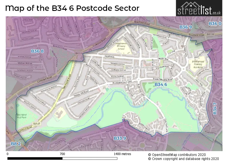
The B34 6 Postcode shares a border with B33 9 (BIRMINGHAM, Stechford, Kitts Green), B34 7 (BIRMINGHAM), B36 9 (BIRMINGHAM, Castle Bromwich), B8 2 (BIRMINGHAM, Washwood Heath, Ward End) and B36 8 (BIRMINGHAM, Ward End).
Map of the B34 6 Postcode Sector
Explore the B34 6 postcode sector by using our interactive map.
The sector is within the post town of BIRMINGHAM.
B34 6 is a postcode sector within the B34 postcode district which is within the B Birmingham postcode area.
The Royal Mail delivery office for the B34 6 postal sector is the Kitts Green Delivery Office.
The area of the B34 6 postcode sector is 0.97 square miles which is 2.52 square kilometres or 622.20 square acres.
Waterways within the B34 6 postcode sector include the River Cole.
Your support helps keep this site running!
If you enjoy using this website, consider buying me a coffee to help cover hosting costs.


| B | 3 | 4 | - | 6 | X | X |
| B | 3 | 4 | Space | 6 | Letter | Letter |
Official List of Streets
BIRMINGHAM (80 Streets)
Buckland End (4 Streets)
Shard End (2 Streets)
(3 Streets)
Unofficial Streets or Alternative Spellings
Weather Forecast for B34 6
Weather Forecast for Castle Bromwich
| Time Period | Icon | Description | Temperature | Rain Probability | Wind |
|---|---|---|---|---|---|
| 06:00 to 09:00 | Overcast | 4.0°C (feels like 2.0°C) | 10.00% | SSE 4 mph | |
| 09:00 to 12:00 | Overcast | 4.0°C (feels like 1.0°C) | 10.00% | S 7 mph | |
| 12:00 to 15:00 | Overcast | 6.0°C (feels like 3.0°C) | 8.00% | S 9 mph | |
| 15:00 to 18:00 | Overcast | 7.0°C (feels like 4.0°C) | 8.00% | S 9 mph | |
| 18:00 to 21:00 | Overcast | 5.0°C (feels like 2.0°C) | 8.00% | SSE 9 mph | |
| 21:00 to 00:00 | Overcast | 4.0°C (feels like 1.0°C) | 8.00% | S 11 mph |
| Time Period | Icon | Description | Temperature | Rain Probability | Wind |
|---|---|---|---|---|---|
| 00:00 to 03:00 | Overcast | 4.0°C (feels like 0.0°C) | 8.00% | S 11 mph | |
| 03:00 to 06:00 | Cloudy | 3.0°C (feels like -1.0°C) | 5.00% | SSE 9 mph | |
| 06:00 to 09:00 | Cloudy | 2.0°C (feels like -2.0°C) | 5.00% | SSE 9 mph | |
| 09:00 to 12:00 | Partly cloudy (day) | 2.0°C (feels like -1.0°C) | 5.00% | SSE 9 mph | |
| 12:00 to 15:00 | Cloudy | 5.0°C (feels like 2.0°C) | 6.00% | S 9 mph | |
| 15:00 to 18:00 | Partly cloudy (day) | 6.0°C (feels like 4.0°C) | 4.00% | SSW 7 mph | |
| 18:00 to 21:00 | Cloudy | 5.0°C (feels like 3.0°C) | 5.00% | SSW 4 mph | |
| 21:00 to 00:00 | Clear night | 4.0°C (feels like 1.0°C) | 2.00% | SSW 7 mph |
| Time Period | Icon | Description | Temperature | Rain Probability | Wind |
|---|---|---|---|---|---|
| 00:00 to 03:00 | Partly cloudy (night) | 3.0°C (feels like 0.0°C) | 2.00% | SSW 7 mph | |
| 03:00 to 06:00 | Cloudy | 3.0°C (feels like 0.0°C) | 5.00% | SSW 7 mph | |
| 06:00 to 09:00 | Overcast | 3.0°C (feels like 0.0°C) | 8.00% | SSW 7 mph | |
| 09:00 to 12:00 | Overcast | 4.0°C (feels like 1.0°C) | 9.00% | SSW 9 mph | |
| 12:00 to 15:00 | Overcast | 7.0°C (feels like 4.0°C) | 8.00% | SSW 11 mph | |
| 15:00 to 18:00 | Cloudy | 8.0°C (feels like 6.0°C) | 5.00% | SSW 11 mph | |
| 18:00 to 21:00 | Cloudy | 7.0°C (feels like 4.0°C) | 5.00% | SSW 9 mph | |
| 21:00 to 00:00 | Cloudy | 6.0°C (feels like 3.0°C) | 6.00% | S 11 mph |
| Time Period | Icon | Description | Temperature | Rain Probability | Wind |
|---|---|---|---|---|---|
| 00:00 to 03:00 | Cloudy | 6.0°C (feels like 3.0°C) | 9.00% | SSW 13 mph | |
| 03:00 to 06:00 | Overcast | 7.0°C (feels like 3.0°C) | 17.00% | SSW 13 mph | |
| 06:00 to 09:00 | Cloudy | 7.0°C (feels like 3.0°C) | 17.00% | SSW 13 mph | |
| 09:00 to 12:00 | Overcast | 7.0°C (feels like 4.0°C) | 22.00% | SSW 13 mph | |
| 12:00 to 15:00 | Overcast | 9.0°C (feels like 6.0°C) | 21.00% | SSW 13 mph | |
| 15:00 to 18:00 | Light rain | 9.0°C (feels like 7.0°C) | 45.00% | SW 11 mph | |
| 18:00 to 21:00 | Partly cloudy (night) | 8.0°C (feels like 6.0°C) | 14.00% | WSW 9 mph | |
| 21:00 to 00:00 | Partly cloudy (night) | 7.0°C (feels like 4.0°C) | 8.00% | WSW 9 mph |
Schools and Places of Education Within the B34 6 Postcode Sector
Beaufort School
Community special school
Stechford Road, Birmingham, West Midlands, B34 6BJ
Head: Ms Nova Harvey
Ofsted Rating: Special Measures
Inspection: 2023-06-28 (584 days ago)
Website: Visit Beaufort School Website
Phone: 01216758500
Number of Pupils: 96
Brownmead Primary Academy
Academy sponsor led
Pencroft Road, Birmingham, West Midlands, B34 6SS
Head: Mrs Wendy Cotterill-Carter
Ofsted Rating: Good
Inspection: 2020-01-09 (1850 days ago)
Website: Visit Brownmead Primary Academy Website
Phone: 01216753102
Number of Pupils: 341
Colebourne Primary School
Community school
Stechford Road, Birmingham, West Midlands, B34 6BJ
Head: Mr Stuart Guest
Ofsted Rating: Good
Inspection: 2019-05-02 (2102 days ago)
Website: Visit Colebourne Primary School Website
Phone: 01216758500
Number of Pupils: 464
Heathlands Primary Academy
Academy converter
Heath Way, Birmingham, West Midlands, B34 6NB
Head: Mr Pete Higgins
Ofsted Rating: Good
Inspection: 2023-06-28 (584 days ago)
Website: Visit Heathlands Primary Academy Website
Phone: 01217472705
Number of Pupils: 424
House Prices in the B34 6 Postcode Sector
| Type of Property | 2018 Average | 2018 Sales | 2017 Average | 2017 Sales | 2016 Average | 2016 Sales | 2015 Average | 2015 Sales |
|---|---|---|---|---|---|---|---|---|
| Detached | £171,000 | 3 | £166,250 | 12 | £201,717 | 9 | £170,250 | 8 |
| Semi-Detached | £175,154 | 75 | £160,532 | 74 | £149,415 | 70 | £139,697 | 75 |
| Terraced | £146,210 | 56 | £137,757 | 59 | £129,021 | 65 | £113,179 | 42 |
| Flats | £96,859 | 11 | £79,300 | 5 | £72,500 | 4 | £79,583 | 6 |
Important Postcodes B34 6 in the Postcode Sector
B34 6BJ is the postcode for Colebourne Primary School, Stechford Road, and Beaufort Special School, Stechford Road
B34 6BP is the postcode for Doctors Surgery, 36 Bucklands End Lane
B34 6NB is the postcode for Heathlands Primary School, Heath Way, KEY STAGE 1, Heathlands Primary Academy, Heath Way, Heathlands Primary Academy, Heath Way, and KEY STAGE 2, Heathlands Primary Academy, Heath Way
B34 6SS is the postcode for BROWNMEAD JUNIOR AND INFANT SCHOOL, PENCROFT ROAD, BIRMINGHAM, Brownmead Junior & Infant School, Pencroft Road, and BROWNMEAD ACADEMY, PENCROFT ROAD, BIRMINGHAM
| The B34 6 Sector is within these Local Authorities |
|
|---|---|
| The B34 6 Sector is within these Counties |
|
| The B34 6 Sector is within these Water Company Areas |
|