
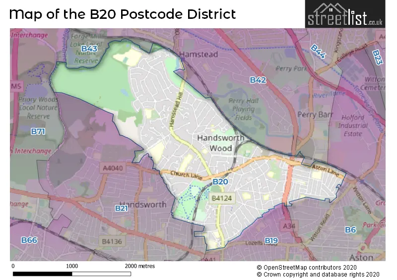
Map of the B20 Postcode District
Explore the postcode district by using our interactive map.
Circles represent recorded crime; the larger the circle, the higher the crime rates.
Your support helps keep this site running!
If you enjoy using this website, consider buying me a coffee to help cover hosting costs.
Where is the B20 District?
To give you an idea where the district is located we have created the following table showing nearby towns.
Nearest Towns to B20
| Town | Distance (miles) | Direction |
|---|---|---|
| Smethwick | 2.59 | SW |
| Birmingham | 2.87 | SSE |
| West Bromwich | 2.98 | W |
| Oldbury | 3.89 | WSW |
| Wednesbury | 4.54 | WNW |
| Tipton | 5.04 | WNW |
| Walsall | 5.22 | NNW |
| Royal Sutton Coldfield | 5.34 | NE |
| Rowley Regis | 5.54 | WSW |
| Blackheath | 5.69 | WSW |
| Darlaston | 5.71 | NW |
| Aldridge | 6.03 | N |
| Dudley | 6.65 | W |
| Coseley | 6.99 | WNW |
| Willenhall | 7.02 | NW |
| Bilston | 7.20 | WNW |
| Halesowen | 7.24 | SW |
| Bloxwich | 7.55 | NNW |
| Brierley Hill | 8.17 | WSW |
| Sedgley | 8.41 | W |
The post town for this district is BIRMINGHAM.
Postcode Information for District B20 (Total Geographical Postcodes: 841)
| Location | Post Town | Sector | Number of Postcodes |
|---|---|---|---|
| BIRMINGHAM | BIRMINGHAM | B20 3 | 245 |
| BIRMINGHAM | BIRMINGHAM | B20 2 | 174 |
| Handsworth | BIRMINGHAM | B20 2 | 170 |
| BIRMINGHAM | BIRMINGHAM | B20 1 | 131 |
| Handsworth | BIRMINGHAM | B20 3 | 120 |
| Handsworth | BIRMINGHAM | B20 1 | 1 |
Retail and Shopping in B20
Street
Town
Locality
Number of Shops
Central Postcode
View on Google Maps
BIRCHFIELD ROAD
BIRMINGHAM
32
B20 3JG
View on Google Maps
COLLEGE ROAD
BIRMINGHAM
HANDSWORTH
23
B20 2HX
View on Google Maps
WELLINGTON ROAD
BIRMINGHAM
HANDSWORTH
19
B20 2QL
View on Google Maps
THE BROADWAY
BIRMINGHAM
16
B20 3ED
View on Google Maps
ASTON LANE
BIRMINGHAM
9
B20 3HS
View on Google Maps
ACFOLD ROAD
BIRMINGHAM
7
B20 1HD
View on Google Maps
SOMERSET ROAD
BIRMINGHAM
HANDSWORTH
6
B20 2JF
View on Google Maps
| Street | Town | Locality | Number of Shops | Central Postcode | View on Google Maps |
|---|---|---|---|---|---|
| BIRCHFIELD ROAD | BIRMINGHAM | 32 | B20 3JG | View on Google Maps | |
| COLLEGE ROAD | BIRMINGHAM | HANDSWORTH | 23 | B20 2HX | View on Google Maps |
| WELLINGTON ROAD | BIRMINGHAM | HANDSWORTH | 19 | B20 2QL | View on Google Maps |
| THE BROADWAY | BIRMINGHAM | 16 | B20 3ED | View on Google Maps | |
| ASTON LANE | BIRMINGHAM | 9 | B20 3HS | View on Google Maps | |
| ACFOLD ROAD | BIRMINGHAM | 7 | B20 1HD | View on Google Maps | |
| SOMERSET ROAD | BIRMINGHAM | HANDSWORTH | 6 | B20 2JF | View on Google Maps |
The primary settlement in the B20 postcode district is Handsworth, located in Birmingham, West Midlands. Other significant settlements in the district include Birmingham itself. The primary post town in the district is Birmingham, also located in the West Midlands county.
When it comes to local government, postal geography often disregards political borders. However, this district intersects the following councils: the district mostly encompasses the Birmingham District (B) area with a total of 534 postal codes.
The largest settlements in the B20 postal code are BIRMINGHAM and Handsworth.
The B20 Postcode shares a border with B21 (BIRMINGHAM, Handsworth), B19 (BIRMINGHAM, Lozells, Handsworth), B42 (BIRMINGHAM, Perry Barr, Great Barr), B6 (BIRMINGHAM, Aston, Witton), B43 (BIRMINGHAM, Great Barr) and B71 (WEST BROMWICH).


Dentists in the B20 District
| # | Name | Address | Type | Contact |
|---|---|---|---|---|
| 1 | Dental Surgery | 94 CHURCH LANE , HANDSWORTH , BIRMINGHAM , WEST MIDLANDS , B20 2ES | GENERAL DENTAL PRACTICE |
Doctors in the B20 District
| # | Name | Address | Type | Contact |
|---|---|---|---|---|
| 1 | Handsworth Wood Med.ctr. | , HANDSWORTH WOOD , BIRMINGHAM , WEST MIDLANDS , B20 2ES | GP PRACTICE | |
| 2 | Hamstead Road Surgery | , HANDSWORTH , BIRMINGHAM , WEST MIDLANDS , B20 2QR | GP PRACTICE | |
| 3 | The Slieve Surgery | , HANDSWORTH WOOD , BIRMINGHAM , WEST MIDLANDS , B20 2NR | GP PRACTICE | |
| 4 | Crompton Road Surgery | , HANDSWORTH , BIRMINGHAM , B20 3QP | BRANCH SURGERY |
Chemists in the B20 District
| # | Name | Address | Type | Contact |
|---|---|---|---|---|
| 1 | Health Plus Pharmacy | 219-221 ASTON LANE , HANDSWORTH , BIRMINGHAM , B20 3HY | PHARMACY | |
| 2 | Wards Chemists | 49 COOPERS ROAD , HANDSWORTH , BIRMINGHAM , WEST MIDLANDS , B20 2JU | PHARMACY | |
| 3 | Healthstop Pharmacy | 168 HAMSTEAD ROAD , HANDSWORTH , BIRMINGHAM , WEST MIDLANDS , B20 2QR | PHARMACY | |
| 4 | Rx Pharmacy | 256 WELLINGTON ROAD , HANDSWORTH , BIRMINGHAM , WEST MIDLANDS , B20 2QL | PHARMACY | |
| 5 | Handsworth Wood Pharmacy | 110-114 CHURCH LANE , HANDSWORTH , BIRMINGHAM , B20 2ES | PHARMACY |
Opticians in the B20 District
| # | Name | Address | Type | Contact |
|---|---|---|---|---|
| 1 | EYES AND VISION | 280 WELLINGTON ROAD , HANDSWORTH , BIRMINGHAM , WEST MIDLANDS , B20 2QL | OPTICAL SITE |
Schools in the Sector
Hamstead Hall Academy
Phase: Secondary
Address: Craythorne Avenue , Handsworth Wood , Birmingham
Postcode: B20 1HL
Headteacher: Mrs Carla Tranter (Heads of School)
Ofsted Rating: Good
Grestone Academy
Phase: Primary
Address: Grestone Avenue , Handsworth Wood , Birmingham
Postcode: B20 1ND
Headteacher: Mrs Deborah Steen (Head of School)
Ofsted Rating: Good
Welford Primary School
Phase: Primary
Address: Welford Road , Handsworth , Birmingham
Postcode: B20 2BL
Headteacher: Mrs Carol Foster (Headteacher)
Ofsted Rating: Good
King Edward VI Handsworth Wood Girls' Academy
Phase: Secondary
Address: Church Lane , Handsworth , Birmingham
Postcode: B20 2HL
Headteacher: Mr Qamar Riaz (Headteacher)
Ofsted Rating: Outstanding
Cherry Orchard Primary School
Phase: Primary
Address: Cherry Orchard Road , Handsworth Wood , Birmingham
Postcode: B20 2LB
Headteacher: Miss Alison Taylor (Headteacher)
Ofsted Rating: Good
St Teresa's Catholic Primary School
Phase: Primary
Address: Butlers Road , Handsworth Wood , Birmingham
Postcode: B20 2NY
Headteacher: Mr Declan Corkery (Headteacher)
Ofsted Rating: Good
St Marys C of E Primary and Nursery, Academy, Handsworth
Phase: Primary
Address: Hamstead Road , Handsworth , Birmingham
Postcode: B20 2RW
Headteacher: Mrs Jo Booker (Headteacher)
Ofsted Rating: Good
Canterbury Cross Primary School
Phase: Primary
Address: Canterbury Road , Birchfield , Birmingham
Postcode: B20 3AA
Headteacher: Mr Khalid Din (Headteacher)
Ofsted Rating: Good
Canterbury Cross Primary School
Phase: Primary
Address: Canterbury Road , Birchfield , Birmingham
Postcode: B20 3AA
Headteacher: Mr Khalid Din (Headteacher)
Ofsted Rating: Good
Sacred Heart Catholic School
Phase: Primary
Address: Earlsbury Gardens , Birchfield , Birmingham
Postcode: B20 3AE
Headteacher: Mr Gerry O'Hara (Headteacher)
Ofsted Rating: Special Measures
Sacred Heart Catholic School
Phase: Primary
Address: Earlsbury Gardens , Birchfield , Birmingham
Postcode: B20 3AE
Headteacher: Mrs Catherine Dalzell ()
Ofsted Rating: Requires improvement
Broadway Academy
Phase: Secondary
Address: The Broadway , Perry Barr , Birmingham
Postcode: B20 3DP
Headteacher: Mr Ronald Skelton (Headteacher)
Ofsted Rating: Good
Holy Trinity CE Primary Academy (Handsworth)
Phase: Primary
Address: Havelock Road , Handsworth , Birmingham
Postcode: B20 3LP
Headteacher: Mrs Paula Burns (Headteacher)
Ofsted Rating: Good
Westminster Primary School
Phase: Primary
Address: Stamford Road , Handsworth , Birmingham
Postcode: B20 3PN
Headteacher: Mr Maneer Samad (Headteacher)
Ofsted Rating: Good
Westminster Primary School
Phase: Primary
Address: Stamford Road , Handsworth , Birmingham
Postcode: B20 3PN
Headteacher: Mr Maneer Samad (Headteacher)
Ofsted Rating: Good
St Clare's Catholic Primary School
Phase: Primary
Address: Robert Road , Handsworth , Birmingham
Postcode: B20 3RT
Headteacher: Mrs Victoria Rivett (Headteacher)
Ofsted Rating: Good
Stations in the Sector
Perry Barr
CRS Code: PRY
Operator: WM
Line: Chase Line
Company:
Accessable Motorway Junctions
M6 J6
Average Driving Time from within the district: 5.90
Average Driving Distance: 3.09
Number of Postcodes that can access the Motorway Junction: 530
M5 J1
Average Driving Time from within the district: 6.30
Average Driving Distance: 2.95
Number of Postcodes that can access the Motorway Junction: 530
M6 J7
Average Driving Time from within the district: 6.62
Average Driving Distance: 3.33
Number of Postcodes that can access the Motorway Junction: 530
M5 J2
Average Driving Time from within the district: 8.24
Average Driving Distance: 4.91
Number of Postcodes that can access the Motorway Junction: 327
M6 J9
Average Driving Time from within the district: 9.01
Average Driving Distance: 6.00
Number of Postcodes that can access the Motorway Junction: 84
M6 J5
Average Driving Time from within the district: 10.22
Average Driving Distance: 5.82
Number of Postcodes that can access the Motorway Junction: 119
Weather Forecast for Brown's Green
| Time Period | Icon | Description | Temperature | Rain Probability | Wind |
|---|---|---|---|---|---|
| 00:00 to 03:00 | Overcast | 4.0°C (feels like 1.0°C) | 10.00% | S 11 mph | |
| 03:00 to 06:00 | Overcast | 4.0°C (feels like 0.0°C) | 9.00% | S 11 mph | |
| 06:00 to 09:00 | Overcast | 4.0°C (feels like 0.0°C) | 8.00% | S 9 mph | |
| 09:00 to 12:00 | Overcast | 3.0°C (feels like 0.0°C) | 8.00% | S 9 mph | |
| 12:00 to 15:00 | Cloudy | 5.0°C (feels like 2.0°C) | 4.00% | S 9 mph | |
| 15:00 to 18:00 | Partly cloudy (day) | 6.0°C (feels like 4.0°C) | 2.00% | SSW 9 mph | |
| 18:00 to 21:00 | Cloudy | 5.0°C (feels like 3.0°C) | 5.00% | SSW 4 mph | |
| 21:00 to 00:00 | Cloudy | 5.0°C (feels like 2.0°C) | 4.00% | SSW 7 mph |
| Time Period | Icon | Description | Temperature | Rain Probability | Wind |
|---|---|---|---|---|---|
| 00:00 to 03:00 | Cloudy | 4.0°C (feels like 1.0°C) | 5.00% | SSW 7 mph | |
| 03:00 to 06:00 | Overcast | 4.0°C (feels like 1.0°C) | 9.00% | SSW 7 mph | |
| 06:00 to 09:00 | Overcast | 4.0°C (feels like 1.0°C) | 8.00% | SSW 7 mph | |
| 09:00 to 12:00 | Overcast | 4.0°C (feels like 1.0°C) | 9.00% | SSW 7 mph | |
| 12:00 to 15:00 | Cloudy | 6.0°C (feels like 4.0°C) | 5.00% | SSW 9 mph | |
| 15:00 to 18:00 | Cloudy | 8.0°C (feels like 5.0°C) | 5.00% | SSW 9 mph | |
| 18:00 to 21:00 | Overcast | 7.0°C (feels like 4.0°C) | 7.00% | SSW 9 mph | |
| 21:00 to 00:00 | Overcast | 6.0°C (feels like 3.0°C) | 8.00% | SSW 11 mph |
| Time Period | Icon | Description | Temperature | Rain Probability | Wind |
|---|---|---|---|---|---|
| 00:00 to 03:00 | Overcast | 6.0°C (feels like 3.0°C) | 8.00% | SSW 11 mph | |
| 03:00 to 06:00 | Overcast | 6.0°C (feels like 3.0°C) | 9.00% | SSW 11 mph | |
| 06:00 to 09:00 | Cloudy | 6.0°C (feels like 3.0°C) | 5.00% | SSW 13 mph | |
| 09:00 to 12:00 | Overcast | 7.0°C (feels like 3.0°C) | 10.00% | SSW 13 mph | |
| 12:00 to 15:00 | Overcast | 9.0°C (feels like 6.0°C) | 19.00% | SSW 13 mph | |
| 15:00 to 18:00 | Light rain | 9.0°C (feels like 7.0°C) | 56.00% | SW 11 mph | |
| 18:00 to 21:00 | Cloudy | 8.0°C (feels like 6.0°C) | 21.00% | SW 9 mph | |
| 21:00 to 00:00 | Clear night | 7.0°C (feels like 4.0°C) | 8.00% | WSW 9 mph |
| Time Period | Icon | Description | Temperature | Rain Probability | Wind |
|---|---|---|---|---|---|
| 00:00 to 03:00 | Clear night | 5.0°C (feels like 2.0°C) | 3.00% | WSW 9 mph | |
| 03:00 to 06:00 | Clear night | 4.0°C (feels like 1.0°C) | 1.00% | W 7 mph | |
| 06:00 to 09:00 | Clear night | 3.0°C (feels like 0.0°C) | 1.00% | W 4 mph | |
| 09:00 to 12:00 | Cloudy | 3.0°C (feels like 1.0°C) | 4.00% | W 4 mph | |
| 12:00 to 15:00 | Cloudy | 6.0°C (feels like 4.0°C) | 4.00% | WNW 4 mph | |
| 15:00 to 18:00 | Cloudy | 7.0°C (feels like 6.0°C) | 4.00% | NW 4 mph | |
| 18:00 to 21:00 | Clear night | 4.0°C (feels like 3.0°C) | 1.00% | WSW 2 mph | |
| 21:00 to 00:00 | Clear night | 3.0°C (feels like 1.0°C) | 1.00% | SE 4 mph |
| Postal Sector | Delivery Office |
|---|---|
| B20 1 | Handsworth Delivery Office |
| B20 2 | Handsworth Delivery Office |
| B20 3 | Handsworth Delivery Office |
| B | 2 | 0 | - | X | X | X |
| B | 2 | 0 | Space | Numeric | Letter | Letter |
Street List for the B20 District
Current Monthly Rental Prices
| # Bedrooms | Min Price | Max Price | Avg Price |
|---|---|---|---|
| £500 | £575 | £538 | |
| 1 | £74 | £650 | £189 |
| 2 | £795 | £900 | £855 |
| 3 | £1,000 | £1,400 | £1,208 |
| 6 | £74 | £74 | £74 |
Current House Prices
| # Bedrooms | Min Price | Max Price | Avg Price |
|---|---|---|---|
| 4 | £450,000 | £800,000 | £537,217 |
| 5 | £449,950 | £875,000 | £573,831 |
| 6 | £650,000 | £650,000 | £650,000 |
| 7 | £550,000 | £550,000 | £550,000 |
| 9 | £675,000 | £675,000 | £675,000 |
Estate Agents
| Logo | Name | Brand Name | Address | Contact Number |
|---|---|---|---|---|
 | Hamstead | Paul Carr | 3 International House, Old Walsall Road, Great Barr, Birmingham, B42 1NN | 0121 387 6411 |
 | Great Barr | Connells | 907 Walsall Road, Great Barr, B42 1TN | 0121 387 6334 |
 | Handsworth | Hunters | 304 Rookery Road, Handsworth, Birmingham, B21 9QG | 0121 387 6455 |
 | Great Barr | Shipways | 905 Walsall Road, Great Barr, B42 1TN | 0121 387 6303 |
 | Covering West Midlands | Homewise | B46 1DL | 01273 092409 |
Yearly House Price Averages for the District
| Type of Property | 2018 Average | 2018 Sales | 2017 Average | 2017 Sales | 2016 Average | 2016 Sales | 2015 Average | 2015 Sales |
|---|---|---|---|---|---|---|---|---|
| Detached | £297,984 | 35 | £256,257 | 33 | £252,858 | 46 | £258,124 | 46 |
| Semi-Detached | £209,608 | 76 | £203,272 | 69 | £175,208 | 92 | £169,367 | 76 |
| Terraced | £145,123 | 124 | £144,382 | 108 | £140,140 | 99 | £122,584 | 98 |
| Flats | £79,788 | 20 | £66,378 | 25 | £71,971 | 25 | £63,878 | 27 |