A wide range of spatial data has been analysed to present this overview of the B16 8 Postcode sector. If you would like anything added, please contact us.
The B16 8 postcode sector is within the county of West Midlands.
Did you know? According to the 2021 Census, the B16 8 postcode sector is home to a bustling 8,499 residents!
Given that each sector allows for 400 unique postcode combinations. Letters C, I, K, M, O and V are not allowed in the last two letters of a postcode. With 164 postcodes already in use, this leaves 236 units available.
The largest settlement in the B16 8 postal code is BIRMINGHAM followed by Edgbaston, and Ladywood.
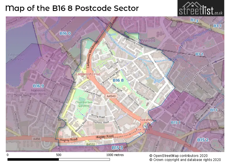
The B16 8 Postcode shares a border with B16 9 (BIRMINGHAM, Edgbaston), B1 2 (BIRMINGHAM), B15 1 (BIRMINGHAM, Edgbaston), B15 3 (Edgbaston, BIRMINGHAM), B16 0 (BIRMINGHAM, Edgbaston) and B18 7 (BIRMINGHAM, Hockley).
Map of the B16 8 Postcode Sector
Explore the B16 8 postcode sector by using our interactive map.
The sector is within the post town of BIRMINGHAM.
B16 8 is a postcode sector within the B16 postcode district which is within the B Birmingham postcode area.
The Royal Mail delivery office for the B16 8 postal sector is the Western (b) Delivery Office.
The area of the B16 8 postcode sector is 0.36 square miles which is 0.93 square kilometres or 228.85 square acres.
Waterways within the B16 8 postcode sector include the Oozel's Loop, Birmingham Canal Navigations, Sherborne Wharf.
Your support helps keep this site running!
If you enjoy using this website, consider buying me a coffee to help cover hosting costs.

| B | 1 | 6 | - | 8 | X | X |
| B | 1 | 6 | Space | 8 | Letter | Letter |
Official List of Streets
BIRMINGHAM (47 Streets)
Ladywood (2 Streets)
Edgbaston (2 Streets)
Unofficial Streets or Alternative Spellings
BIRMINGHAM
BROAD STREET BRUNSWICK SQUARE COPE STREET HARBORNE ROAD ICKNIELD PORT ROAD ICKNIELD SQUARE KELSALL CROFT NOEL ROAD PARKER STREET PLOUGH & HARROW ROAD WATERWORKS ROADEdgbaston
HAGLEY ROAD HIGHFIELD ROAD RESERVOIR ROAD VICARAGE ROAD BRUNSWICK ARCADE FIVE WAYS LADYWOOD CIRCUS MONUMENT ROAD BASIN BRIDGE PLOUGH AND HARROW ROAD ST MARKS CRESCENT ST VINCENT STREET BRIDGE WATERSIDE COURTLadywood
OLIVER ROADWeather Forecast for B16 8
Weather Forecast for Chad Valley
| Time Period | Icon | Description | Temperature | Rain Probability | Wind |
|---|---|---|---|---|---|
| 03:00 to 06:00 | Overcast | 4.0°C (feels like 0.0°C) | 9.00% | S 11 mph | |
| 06:00 to 09:00 | Overcast | 3.0°C (feels like 0.0°C) | 8.00% | S 9 mph | |
| 09:00 to 12:00 | Cloudy | 3.0°C (feels like 0.0°C) | 8.00% | S 9 mph | |
| 12:00 to 15:00 | Partly cloudy (day) | 5.0°C (feels like 2.0°C) | 2.00% | S 11 mph | |
| 15:00 to 18:00 | Partly cloudy (day) | 6.0°C (feels like 3.0°C) | 2.00% | SSW 9 mph | |
| 18:00 to 21:00 | Cloudy | 5.0°C (feels like 3.0°C) | 6.00% | SSW 7 mph | |
| 21:00 to 00:00 | Cloudy | 4.0°C (feels like 2.0°C) | 5.00% | SSW 7 mph |
| Time Period | Icon | Description | Temperature | Rain Probability | Wind |
|---|---|---|---|---|---|
| 00:00 to 03:00 | Overcast | 4.0°C (feels like 1.0°C) | 8.00% | SSW 7 mph | |
| 03:00 to 06:00 | Overcast | 3.0°C (feels like 1.0°C) | 8.00% | SSW 7 mph | |
| 06:00 to 09:00 | Overcast | 3.0°C (feels like 0.0°C) | 9.00% | SSW 7 mph | |
| 09:00 to 12:00 | Overcast | 4.0°C (feels like 1.0°C) | 9.00% | SSW 9 mph | |
| 12:00 to 15:00 | Cloudy | 6.0°C (feels like 3.0°C) | 5.00% | SSW 9 mph | |
| 15:00 to 18:00 | Cloudy | 8.0°C (feels like 5.0°C) | 5.00% | SSW 9 mph | |
| 18:00 to 21:00 | Overcast | 7.0°C (feels like 4.0°C) | 7.00% | SSW 9 mph | |
| 21:00 to 00:00 | Overcast | 6.0°C (feels like 3.0°C) | 7.00% | SSW 11 mph |
| Time Period | Icon | Description | Temperature | Rain Probability | Wind |
|---|---|---|---|---|---|
| 00:00 to 03:00 | Overcast | 6.0°C (feels like 3.0°C) | 8.00% | SSW 11 mph | |
| 03:00 to 06:00 | Overcast | 6.0°C (feels like 3.0°C) | 8.00% | SSW 13 mph | |
| 06:00 to 09:00 | Cloudy | 6.0°C (feels like 2.0°C) | 7.00% | SSW 13 mph | |
| 09:00 to 12:00 | Overcast | 7.0°C (feels like 3.0°C) | 10.00% | SSW 13 mph | |
| 12:00 to 15:00 | Overcast | 9.0°C (feels like 6.0°C) | 18.00% | SSW 13 mph | |
| 15:00 to 18:00 | Light rain | 9.0°C (feels like 6.0°C) | 55.00% | SW 11 mph | |
| 18:00 to 21:00 | Light rain | 8.0°C (feels like 5.0°C) | 49.00% | SW 9 mph | |
| 21:00 to 00:00 | Clear night | 6.0°C (feels like 4.0°C) | 8.00% | WSW 9 mph |
| Time Period | Icon | Description | Temperature | Rain Probability | Wind |
|---|---|---|---|---|---|
| 00:00 to 03:00 | Clear night | 5.0°C (feels like 2.0°C) | 3.00% | WSW 7 mph | |
| 03:00 to 06:00 | Clear night | 4.0°C (feels like 1.0°C) | 1.00% | W 7 mph | |
| 06:00 to 09:00 | Clear night | 2.0°C (feels like 0.0°C) | 1.00% | W 4 mph | |
| 09:00 to 12:00 | Cloudy | 3.0°C (feels like 1.0°C) | 4.00% | W 4 mph | |
| 12:00 to 15:00 | Cloudy | 6.0°C (feels like 4.0°C) | 4.00% | WNW 4 mph | |
| 15:00 to 18:00 | Cloudy | 7.0°C (feels like 6.0°C) | 4.00% | NW 4 mph | |
| 18:00 to 21:00 | Clear night | 4.0°C (feels like 3.0°C) | 1.00% | SW 2 mph | |
| 21:00 to 00:00 | Clear night | 3.0°C (feels like 1.0°C) | 1.00% | SE 4 mph |
Schools and Places of Education Within the B16 8 Postcode Sector
St George's Church of England Primary School
Academy sponsor led
Beaufort Road, Birmingham, West Midlands, B16 8HY
Head: Mr Daniel Rogers
Ofsted Rating: Good
Inspection: 2022-05-11 (998 days ago)
Website: Visit St George's Church of England Primary School Website
Phone: 01214642789
Number of Pupils: 212
St John's & St Peter's CofE Academy
Academy sponsor led
St Vincent Street West, Birmingham, West Midlands, B16 8RN
Head: Mrs Nilam Hullait
Ofsted Rating: Good
Inspection: 2018-06-07 (2432 days ago)
Website: Visit St John's & St Peter's CofE Academy Website
Phone: 01216751398
Number of Pupils: 210
House Prices in the B16 8 Postcode Sector
| Type of Property | 2018 Average | 2018 Sales | 2017 Average | 2017 Sales | 2016 Average | 2016 Sales | 2015 Average | 2015 Sales |
|---|---|---|---|---|---|---|---|---|
| Detached | £0 | 0 | £110,000 | 1 | £0 | 0 | £0 | 0 |
| Semi-Detached | £205,000 | 2 | £126,000 | 1 | £370,000 | 2 | £0 | 0 |
| Terraced | £182,813 | 8 | £166,930 | 5 | £234,882 | 9 | £199,063 | 12 |
| Flats | £200,865 | 293 | £172,989 | 144 | £148,866 | 397 | £164,123 | 180 |
Important Postcodes B16 8 in the Postcode Sector
B16 8AJ is the postcode for Brasshouse Language Centre, 50 Sheepcote Street
B16 8EB is the postcode for The Lawns, 102 St. Vincent Street
B16 8HS is the postcode for Health & Safety Executive, Metropolitan House, 1 Hagley Road
B16 8HY is the postcode for St. Georges C of E Primary School, Beaufort Road, and St. Georges C of E Primary School, Beaufort Road, Edgbaston
B16 8JJ is the postcode for Norman Power Centre, Skipton Road
B16 8PE is the postcode for Tribunals Service, 54 Hagley Road
B16 8QG is the postcode for Redundancy Payments Office, Cobalt Square, 83 Hagley Road
B16 8RN is the postcode for St. Johns C of E Junior & Infant School, St. Vincent Street West
B16 8RP is the postcode for Ladywood Community Centre, St. Vincent Street West
B16 8RQ is the postcode for Marywood Centre, Gilby Road
B16 8SY is the postcode for West Midlands Police, Ladywood Police Station, 170 Ladywood Middleway
B16 8TR is the postcode for Ladywood Leisure Centre, Ladywood Middleway, and Ladywood Arts & Leisure Centre, 316 Monument Road
B16 8US is the postcode for Royal Mail, Western Delivery Office, 11 Plough & Harrow Road
| The B16 8 Sector is within these Local Authorities |
|
|---|---|
| The B16 8 Sector is within these Counties |
|
| The B16 8 Sector is within these Water Company Areas |
|