A wide range of spatial data has been analysed to present this overview of the B15 2 Postcode sector. If you would like anything added, please contact us.
The B15 2 postcode sector is within the county of West Midlands.
Did you know? According to the 2021 Census, the B15 2 postcode sector is home to a bustling 11,376 residents!
Given that each sector allows for 400 unique postcode combinations. Letters C, I, K, M, O and V are not allowed in the last two letters of a postcode. With 218 postcodes already in use, this leaves 182 units available.
The largest settlements in the B15 2 postal code are BIRMINGHAM and Edgbaston.
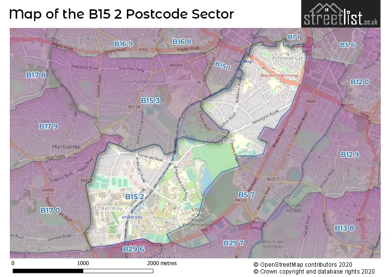
The B15 2 Postcode shares a border with B29 7 (Selly Park, BIRMINGHAM, Selly Oak), B1 1 (BIRMINGHAM), B5 7 (BIRMINGHAM, Edgbaston), B15 1 (BIRMINGHAM, Edgbaston), B15 3 (Edgbaston, BIRMINGHAM), B17 0 (BIRMINGHAM, Harborne) and B29 6 (BIRMINGHAM, Selly Oak).
Map of the B15 2 Postcode Sector
Explore the B15 2 postcode sector by using our interactive map.
The sector is within the post town of BIRMINGHAM.
B15 2 is a postcode sector within the B15 postcode district which is within the B Birmingham postcode area.
The Royal Mail delivery office for the B15 2 postal sector is the Western (b) Delivery Office.
The area of the B15 2 postcode sector is 1.43 square miles which is 3.71 square kilometres or 915.59 square acres.
Waterways within the B15 2 postcode sector include the Worcester & Birmingham Canal, Bourn Brook.
Your support helps keep this site running!
If you enjoy using this website, consider buying me a coffee to help cover hosting costs.

| B | 1 | 5 | - | 2 | X | X |
| B | 1 | 5 | Space | 2 | Letter | Letter |
Official List of Streets
BIRMINGHAM (70 Streets)
Edgbaston (21 Streets)
Unofficial Streets or Alternative Spellings
BIRMINGHAM
BELGRAVE MIDDLEWAY HARBORNE PARK ROAD HOLLOWAY HEAD IRVING STREET MEAD RISE QUEENS HOSPITAL CLOSE RICHMOND HILL ROAD SUTTON STREET VICEROY CLOSE WOODLEIGH AVENUE BOURN BROOK WALKWAY EDENCROFT ESTERIA ROAD HARRISONS ROAD HOSPITAL WAY KELTON COURT LEE MOUNT MONACO HOUSE UNDERPASS PARK VALE DRIVE RING ROAD NORTH RING ROAD SOUTH SOUTH WEST CAMPUS SPUR ROAD TENNIS COURT TERRACE ROAD THE ASH PATH THE BEECHES THE EDG UNIVERSITY ROAD EAST UNIVERSITY ROAD WEST UNIVERSITY SQUARE WARWICK CREST WEST GATEEdgbaston
CHURCH ROAD ISLINGTON ROW MIDDLEWAY MINDELSOHN WAYSelly Oak
BRISTOL ROADHarborne
HARBORNE LANEWeather Forecast for B15 2
Weather Forecast for Winterbourne
| Time Period | Icon | Description | Temperature | Rain Probability | Wind |
|---|---|---|---|---|---|
| 00:00 to 03:00 | Overcast | 4.0°C (feels like 0.0°C) | 9.00% | S 9 mph | |
| 03:00 to 06:00 | Overcast | 4.0°C (feels like 0.0°C) | 9.00% | S 9 mph | |
| 06:00 to 09:00 | Overcast | 3.0°C (feels like 0.0°C) | 8.00% | S 9 mph | |
| 09:00 to 12:00 | Cloudy | 3.0°C (feels like 0.0°C) | 8.00% | S 7 mph | |
| 12:00 to 15:00 | Partly cloudy (day) | 6.0°C (feels like 2.0°C) | 2.00% | S 9 mph | |
| 15:00 to 18:00 | Partly cloudy (day) | 7.0°C (feels like 4.0°C) | 2.00% | SSW 9 mph | |
| 18:00 to 21:00 | Cloudy | 5.0°C (feels like 3.0°C) | 5.00% | SSW 4 mph | |
| 21:00 to 00:00 | Cloudy | 5.0°C (feels like 2.0°C) | 4.00% | SSW 7 mph |
| Time Period | Icon | Description | Temperature | Rain Probability | Wind |
|---|---|---|---|---|---|
| 00:00 to 03:00 | Overcast | 4.0°C (feels like 1.0°C) | 8.00% | SSW 7 mph | |
| 03:00 to 06:00 | Overcast | 4.0°C (feels like 1.0°C) | 8.00% | SSW 7 mph | |
| 06:00 to 09:00 | Overcast | 4.0°C (feels like 1.0°C) | 9.00% | SSW 7 mph | |
| 09:00 to 12:00 | Overcast | 4.0°C (feels like 1.0°C) | 9.00% | SSW 7 mph | |
| 12:00 to 15:00 | Cloudy | 7.0°C (feels like 4.0°C) | 5.00% | SSW 9 mph | |
| 15:00 to 18:00 | Cloudy | 8.0°C (feels like 6.0°C) | 5.00% | SSW 9 mph | |
| 18:00 to 21:00 | Overcast | 7.0°C (feels like 4.0°C) | 7.00% | SSW 9 mph | |
| 21:00 to 00:00 | Overcast | 6.0°C (feels like 3.0°C) | 7.00% | SSW 9 mph |
| Time Period | Icon | Description | Temperature | Rain Probability | Wind |
|---|---|---|---|---|---|
| 00:00 to 03:00 | Overcast | 6.0°C (feels like 3.0°C) | 8.00% | SSW 11 mph | |
| 03:00 to 06:00 | Overcast | 6.0°C (feels like 3.0°C) | 8.00% | SSW 11 mph | |
| 06:00 to 09:00 | Cloudy | 6.0°C (feels like 3.0°C) | 7.00% | SSW 11 mph | |
| 09:00 to 12:00 | Overcast | 7.0°C (feels like 3.0°C) | 10.00% | SSW 11 mph | |
| 12:00 to 15:00 | Overcast | 9.0°C (feels like 6.0°C) | 18.00% | SSW 11 mph | |
| 15:00 to 18:00 | Light rain | 9.0°C (feels like 7.0°C) | 55.00% | SW 11 mph | |
| 18:00 to 21:00 | Light rain | 8.0°C (feels like 5.0°C) | 49.00% | SW 9 mph | |
| 21:00 to 00:00 | Clear night | 6.0°C (feels like 4.0°C) | 8.00% | WSW 7 mph |
| Time Period | Icon | Description | Temperature | Rain Probability | Wind |
|---|---|---|---|---|---|
| 00:00 to 03:00 | Clear night | 5.0°C (feels like 2.0°C) | 3.00% | WSW 7 mph | |
| 03:00 to 06:00 | Clear night | 4.0°C (feels like 1.0°C) | 1.00% | W 7 mph | |
| 06:00 to 09:00 | Clear night | 2.0°C (feels like 0.0°C) | 1.00% | W 4 mph | |
| 09:00 to 12:00 | Cloudy | 3.0°C (feels like 1.0°C) | 4.00% | W 4 mph | |
| 12:00 to 15:00 | Cloudy | 6.0°C (feels like 5.0°C) | 4.00% | WNW 7 mph | |
| 15:00 to 18:00 | Cloudy | 7.0°C (feels like 6.0°C) | 4.00% | NW 7 mph | |
| 18:00 to 21:00 | Clear night | 4.0°C (feels like 3.0°C) | 1.00% | SW 4 mph | |
| 21:00 to 00:00 | Clear night | 3.0°C (feels like 2.0°C) | 1.00% | SE 4 mph |
Schools and Places of Education Within the B15 2 Postcode Sector
City Academy
Free schools
23 Langley Walk, Birmingham, West Midlands, B15 2EF
Head: Mrs Rebecca Bakewell
Ofsted Rating: Requires improvement
Inspection: 2023-03-08 (697 days ago)
Website: Visit City Academy Website
Phone: 01217297160
Number of Pupils: 737
James Brindley School
Academy special converter
Bell Barn Road, Birmingham, West Midlands, B15 2AF
Head: Mr Hardip Bissell
Ofsted Rating: Good
Inspection: 2022-06-29 (949 days ago)
Website: Visit James Brindley School Website
Phone: 01216666409
Number of Pupils: 138
Oasis Academy Woodview
Academy sponsor led
Woodview Drive, Birmingham, West Midlands, B15 2HU
Head: Mr Joseph Broadfield
Ofsted Rating: Requires improvement
Inspection: 2022-09-14 (872 days ago)
Website: Visit Oasis Academy Woodview Website
Phone: 01214404202
Number of Pupils: 417
St Catherine of Siena Catholic Primary School
Voluntary aided school
Great Colmore Street, Birmingham, West Midlands, B15 2AY
Head: Mr Edward McNamara
Ofsted Rating: Good
Inspection: 2023-11-08 (452 days ago)
Website: Visit St Catherine of Siena Catholic Primary School Website
Phone: 01216921051
Number of Pupils: 249
St Thomas Centre Nursery School
Local authority nursery school
Bell Barn Road, Birmingham, West Midlands, B15 2AF
Head: Mr Stuart Brown
Ofsted Rating: Outstanding
Inspection: 2023-02-14 (719 days ago)
Website: Visit St Thomas Centre Nursery School Website
Phone: 01214640003
Number of Pupils: 117
House Prices in the B15 2 Postcode Sector
| Type of Property | 2018 Average | 2018 Sales | 2017 Average | 2017 Sales | 2016 Average | 2016 Sales | 2015 Average | 2015 Sales |
|---|---|---|---|---|---|---|---|---|
| Detached | £1,021,443 | 22 | £715,689 | 20 | £662,562 | 13 | £792,132 | 19 |
| Semi-Detached | £498,355 | 5 | £433,206 | 5 | £359,830 | 11 | £394,435 | 7 |
| Terraced | £270,993 | 15 | £282,706 | 18 | £292,550 | 20 | £224,509 | 21 |
| Flats | £217,219 | 324 | £176,818 | 115 | £157,046 | 98 | £155,369 | 122 |
Important Postcodes B15 2 in the Postcode Sector
B15 2AF is the postcode for St. Thomas Childrens Centre, Bell Barn Road, Optima Community Association, St. Thomas House, 80 Bell Barn Road, and St. Thomas Centre Nursery, Bell Barn Road
B15 2AT is the postcode for St. Thomas's C of E Junior & Infant School, Great Colmore Street
B15 2AY is the postcode for St. Catherines RC Junior & Infant School, Great Colmore Street, and St. Catherine of Siena Catholic Primary School, Great Colmore Street
B15 2EF is the postcode for City Academy Birmingham, 23 Langley Walk
B15 2HU is the postcode for Oasis Academy Woodview, Woodview Drive, and Woodview Primary School, Woodview Drive
B15 2QQ is the postcode for The Edgbaston Hospital, 22 Somerset Road, Edgbaston
B15 2QU is the postcode for Occupational Health Services, 13 Pritchatts Road, 7, Pritchatts Road, ASHCROFT FLATS, Flat 1 Ashcroft, Pritchatts Road, 9 PRITCHATTS ROAD, 9 Pritchatts Road, 5, Pritchatts Road, THE SPINNEY, Flat 1 The Spinney, Pritchatts Road, and 31 Pritchatts Road, University of Birmingham
B15 2QW is the postcode for OAKLEY COURT, Flat 1 Oakley Court, Pritchatts Road
B15 2QX is the postcode for PRITCHATTS PARK SOCIAL CENTRE, University of Birmingham, Pritchatts House, 9a Pritchatts Road, and PRITCHATTS HOUSE, University of Birmingham, Pritchatts House, 9a Pritchatts Road
B15 2QZ is the postcode for Birmingham And Solihull Mental Health NHS Trust, Queen Elizabeth Psychiatric Hospital
B15 2RA is the postcode for PETER SCOTT HOUSE, Lucas House Conference Centre, 48 Edgbaston Park Road, and Lucas House Conference Centre, 48 Edgbaston Park Road
B15 2RB is the postcode for CENTRE COURT, 103, Tennis Court, Edgbaston Park Road
B15 2RE is the postcode for TENNIS COURT, Flat 1 Block 1, Tennis Court
B15 2RQ is the postcode for Mason Student Residences, Edgbaston Park Road
B15 2RS is the postcode for HORNTON GRANGE, 53, Edgbaston Park Road, BLOCK 400 GARTH HOUSE, 53, Edgbaston Park Road, GARTH HOUSE, 47, Edgbaston Park Road, and BLOCK 500 GARTH HOUSE, 53, Edgbaston Park Road
B15 2RT is the postcode for Westmere House, 50 Edgbaston Park Road, NICOLSON BUILDING, University of Birmingham, Winterbourne Botanic Garden, 58 Edgbaston Park Road, 40, Edgbaston Park Road, University of Birmingham, Priorsfield, 46 Edgbaston Park Road, and WINTERBOURNE HOUSE, University of Birmingham, Winterbourne Botanic Garden, 58 Edgbaston Park Road
B15 2SA is the postcode for 54 PRITCHATTS ROAD UNIVERSITY OF BIRMINGHAM, 54, Pritchatts Road
B15 2SD is the postcode for University of Birmingham, 32 Pritchatts Road
B15 2SE is the postcode for European Research Institute, Pritchatts Road, and University of Birmingham, Health Centre, Pritchatts Road
B15 2SF is the postcode for Metallurgy and Materials, Pritchatts Road, Gisbert Kapp Building, 52 Pritchatts Road, and IRC Net Shape Manufacturing, Pritchatts Road
B15 2SG is the postcode for Barberry Centre, 25 Vincent Drive, and National Blood Service, Birmingham Centre, Vincent Drive
B15 2SP is the postcode for 90 Vincent Drive, Edgbaston Campus, and The Henry Wellcome Building, Vincent Drive
B15 2SY is the postcode for Birmingham & Solihull Mental Health NHS Trust, 6 Mindelsohn Crescent, Edgbaston, and Birmingham & Solihull Mental Health NHS Trust, 6 Mindelsohn Crescent
B15 2TA is the postcode for Building Health & Employment Learning Hub, 180 Metchley Lane
B15 2TG is the postcode for NORTON COURT, Birmingham Women's NHS Foundation Trust, Birmingham Womens, Birmingham Women's NHS Foundation Trust, Birmingham Womens, and Birmingham Women's NHS Foundation Trust, Birmingham Womens, Metchley Park Road
B15 2TH is the postcode for MAIN HOSPITAL BUILDING, University Hospital Birmingham NHS Foundation Trust, Queen Elizabeth Hospital, HERITAGE BUILDING, University Hospital Birmingham NHS Foundation Trust, Queen Elizabeth Hospital, MORRIS CENTRE, University Hospital Birmingham NHS Foundation Trust, Queen Elizabeth Hospital, MORRIS HOUSE, University Hospital Birmingham NHS Foundation Trust, Queen Elizabeth Hospital, University Hospital Birmingham NHS Foundation Trust, Queen Elizabeth Hospital, and POSTGRADUATE MEDICAL CENTRE, University Hospital Birmingham NHS Foundation Trust, Queen Elizabeth Hospital
B15 2TJ is the postcode for ADVANCED THERAPIES FACILITY, University of Birmingham, Medical School,, INSTITUTE FOR BIOMEDICAL RESEARCH & MEDICAL SCHOOL EXTENSION, University of Birmingham, Medical School,, CANCER RESEARCH & DENIS HOWELL BUILDING, University of Birmingham, Medical School,, ROBERT AITKEN INSTITUTE OF CLINICAL RESEARCH, University of Birmingham, Medical School,, and MEDICAL SCHOOL & STUDENT FACILITIES, University of Birmingham, Medical School,
B15 2TS is the postcode for Barber Institute of Fine Arts, University of Birmingham,
B15 2TT is the postcode for BIOCHEMICAL ENGINEERING, University of Birmingham, Edgbaston, ASHLEY BUILDING, University of Birmingham, Edgbaston, PHYSICS WEST, University of Birmingham, Edgbaston, PHYSICS EAST, University of Birmingham, Edgbaston, Public Health and Occupational Health, Edgbaston Campus, MUNROW SPORTS CENTRE, University of Birmingham, Edgbaston, BIOSCIENCES, University of Birmingham, Edgbaston, LIBRARY, University of Birmingham, Edgbaston, THE SCHOOL OF SPORT & EXERCISE, University of Birmingham, Edgbaston, ST FRANCIS HALL, University of Birmingham, Edgbaston, CHEMICAL ENG. LAB. & WORKSHOP, University of Birmingham, Edgbaston, UNION BUILDING, University of Birmingham, Edgbaston, LEARNING CENTRE & PRIMARY CARE CLINICAL SCIENCES, University of Birmingham, Edgbaston, FRANKLAND BUILDING, University of Birmingham, Edgbaston, STRATHCONA BUILDING, University of Birmingham, Edgbaston, MEDICAL PHYSICS BUILDING, University of Birmingham, Edgbaston, MUIRHEAD TOWER, University of Birmingham, Edgbaston, NUFFIELD BUILDING, University of Birmingham, Edgbaston, STAFF HOUSE, University of Birmingham, Edgbaston, GEOGRAPHY & ENVIRONMENTAL SCIENCES, University of Birmingham, Edgbaston, ASTON WEBB C BLOCK, University of Birmingham, Edgbaston, EDUCATION BUILDING, University of Birmingham, Edgbaston, LAW BUILDING, University of Birmingham, Edgbaston, WATSON BUILDING, University of Birmingham, Edgbaston, UNIVERSITY CENTRE, University of Birmingham, Edgbaston, ASTON WEBB BUILDING, University of Birmingham, Edgbaston, AITCHISON BUILDING, University of Birmingham, Edgbaston, CIVIL ENGINEERING LABORATORIES, University of Birmingham, Edgbaston, MECHANICAL & CIVIL ENGINEERING, University of Birmingham, Edgbaston, CHEMISTRY WEST, University of Birmingham, Edgbaston, J G SMITH BUILDING, University of Birmingham, Edgbaston, TERRACE HUTS, University of Birmingham, Edgbaston, POYNTING PHYSICS, University of Birmingham, Edgbaston, Bramall Music Building, University of Birmingham, OLD GYMNASIUM, University of Birmingham, Edgbaston, ARTS BUILDING, University of Birmingham, Edgbaston, HILLS BUILDING, University of Birmingham, Edgbaston, COMPUTER SCIENCE BUILDING, University of Birmingham, Edgbaston, HAWORTH BUILDING, University of Birmingham, Edgbaston, CHEMICAL ENGINEERING, University of Birmingham, Edgbaston, and Bristol Road Sports Pavilion
B15 2TY is the postcode for Birmingham Business School, University House, 116 Edgbaston Park Road
B15 2WB is the postcode for New Queen Elizabeth Hospital, Mindlesohn Way, and New Queen Elizabeth Hospital, Mindlesohn Way, Edgbaston
| The B15 2 Sector is within these Local Authorities |
|
|---|---|
| The B15 2 Sector is within these Counties |
|
| The B15 2 Sector is within these Water Company Areas |
|