A wide range of spatial data has been analysed to present this overview of the AB15 8 Postcode sector. If you would like anything added, please contact us.
Given that each sector allows for 400 unique postcode combinations. Letters C, I, K, M, O and V are not allowed in the last two letters of a postcode. With 282 postcodes already in use, this leaves 118 units available.
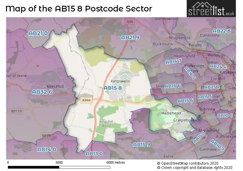
The largest settlement in the AB15 8 postal code is ABERDEEN followed by Kingswells, and Hazlehead.
The AB15 8 Postcode shares a border with AB15 7 (ABERDEEN), AB14 0 (PETERCULTER), AB13 0 (MILLTIMBER), AB15 4 (ABERDEEN), AB15 6 (ABERDEEN), AB15 9 (Cults, Bieldside), AB16 6 (ABERDEEN), AB16 7 (ABERDEEN), AB21 0 (Newmachar, Blackburn, Dyce), AB21 9 (Bucksburn, Stoneywood, ABERDEEN) and AB32 6 (WESTHILL, Elrick, Skene).
Map of the AB15 8 Postcode Sector
Explore the AB15 8 postcode sector by using our interactive map.
The sector is within the post town of ABERDEEN.
AB15 8 is a postcode sector within the AB15 postcode district which is within the AB Aberdeen postcode area.
The Royal Mail delivery office for the AB15 8 postal sector is the Mastrick Delivery Office.
The area of the AB15 8 postcode sector is 11.23 square miles which is 29.09 square kilometres or 7,188.95 square acres.
Your support helps keep this site running!
If you enjoy using this website, consider buying me a coffee to help cover hosting costs.


| A | B | 1 | 5 | - | 8 | X | X |
| A | B | 1 | 5 | Space | 8 | Letter | Letter |
Official List of Streets
ABERDEEN (97 Streets)
Kingswells (74 Streets)
Craigiebuckler (2 Streets)
Unofficial Streets or Alternative Spellings
ABERDEEN
ANGUSFIELD AVENUE CRAIGDEN HILL OF RUBISLAW KINGS GATE LANG STRACHT NORTHBURN AVENUE WESTHOLME AVENUE WOODEND CRESCENT ABERDEEN WESTERN PERIPHERAL ROUTE ANGUSFIELD LANE BLACKTOP ROAD BORROWSTONE ROAD BUS GATE CHAPEL OF STONEYWOOD - FAIRLEY ROAD CULTS - KINGSHILL ROAD FIFESHILL PLACEW HAZELDENE ROAD HAZLEDENE MANOR KINGS GATE KINGSWELL NORTH JUNCTION LINK KINGSWELLS CRESCENT KINGSWELLS DRIVE KINGSWELLS NORTH ROUNDABOUT MEMORY PATH NEW COUNTESSWELLS ROAD PINE TREET GARDENS SKENE ROAD VILLAGE CENTRE WESTHILL CYCLE PATHCults
KIRK BRAEWESTHILL
HILLSIDE ROAD WESTHILL ROADWeather Forecast for AB15 8
Weather Forecast for Westhill
| The AB15 8 Sector is within these Local Authorities | |
|---|---|
| The AB15 8 Sector is within these Counties | |
| The AB15 8 Sector is within these Water Company Areas |